Showing 1–12 of 235 results
-
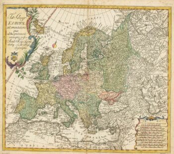
18th century map of Europe
£440EULER, Leonhard.
Published In 1760
Stock No. 24111 -

The First Edition of Ortelius’s map of the Spice Islands
£4,000ORTELIUS, Abraham.
Published In 1570
Stock No. 24431 -

Two-sheet map of Africa
£1,200JAILLOT, Alexis-Hubert.
Published In 1705
Stock No. 24063 -

Victorian map of China with views of Hong Kong and Canton
£250TALLIS, John.
Published In 1851
Stock No. 23537 -

A pictorial map of Beijing in the 1930s
£3,000DORN, Frank.
Published In 1936
Stock No. 24392 -

First issue of Rumold Mercator’s map of Europe
£2,500MERCATOR, Rumold.
Published In 1595
Stock No. 24298 -

The map of China from the first English atlas of the world
£3,700SPEED, John.
Published In 1665
Stock No. 23978 -

19th century Spanish sea chart of the Yellow Sea and Korea
£2,200BRYANT, Tomas.
Published In 1866
Stock No. 12450 -

A 19th century American sea chart of Hong Kong
£3,500BREWER, H.G.
Published In 1916
Stock No. 23973 -

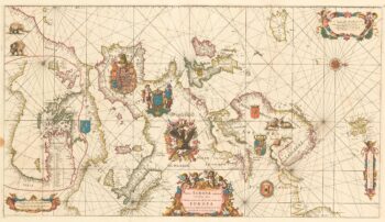
An exceptional 17th century sea chart of Europe on two sheets
£7,500DE WIT, Frederick.
Published In 1675
Stock No. 23450 -

A two-sheet map of Europe
£1,000JAILLOT, Alexis-Hubert.
Published In 1705
Stock No. 24059 -

A detailed map of Victoria in the 1930s
£4,500WAR OFFICE.
Published In 1930
Stock No. 23458