- Reset all
- Africa
- Andalusia
- Antarctic
- Antigua
- Bahamas
- Benelux
- Berkshire
- Bohemia
- Calabria
- Caspian Sea
- Central America
- China
- Europe
- Falklands
- Georgia
- Hertfordshire
- Holy Land
- Indian Ocean
- Latvia and Estonia
- Liguria
- Luxembourg
- Monaco
- Munster
- New York
- North Africa
- Northern Italy
- Nottinghamshire
- Sardinia
- Scandinavia
- Scientific Instruments
- Scottish Islands
- Singapore
- Texas
- Trentino
- West Indies
- Western Europe
- Wiltshire
Showing 1–12 of 1192 results
-

A geological map of the Duchy of Tyrol
£2,350STOTTER, Michael.
Published In 1851
Stock No. 23050 -
16th century map of the Eastern Mediterranean in rare early colour
£880MUNSTER, Sebastian.
Published In 1550
Stock No. 24441 -

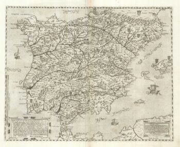
A two-sheet ‘Lafreri-School’ important map of Iberia
£9,750FORLANI, Paolo.
Published In 1567
Stock No. 24477 -

A 17th century chart of the eastern Mediterranean in fine colour.
£1,600DE WIT, Frederick.
Published In 1745
Stock No. 24490 -

de Hooghe’s spectacular chart of the Mediterranean Sea
£36,500HOOGHE, Romeyn de.
Published In 1694
Stock No. 24488 -

Uncommon 16th century Italian map of Cyprus
£1,600ROSACCIO, Giuseppe.
Published In 1598
Stock No. 24538 -

A rare lifetime printing of Blaeu’s view of Vesuvius erupting in 1631
£1,400BLAEU, Johannes.
Published In 1663
Stock No. 24506 -

A rare wall map of the Holy Land
£9,000NOLIN, Jean Baptiste.
Published In 1785
Stock No. 24500 -

A monumental 18th century wall map of Switzerland on four sheets
£6,500SCHEUCHZER, Johann Jakob.
Published In 1712
Stock No. 24499 -

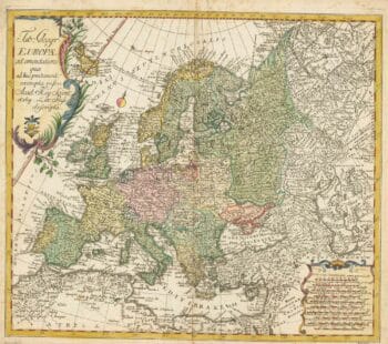
18th century map of Europe
£440EULER, Leonhard.
Published In 1760
Stock No. 24111 -

An incunable prospect of Prague
£1,450SCHEDEL, D. Hartmann.
Published In 1493
Stock No. 24451 -

An incunable prospect of Jerusalem
£1,600SCHEDEL, D. Hartmann.
Published In 1493
Stock No. 24425