Showing 37–48 of 783 results
-

18th century pocket map of Africa
£420SEUTTER, Matthaus.
Published In 1760
Stock No. 18937 -

Ortelius’s pocket atlas with the Galle maps in fine colour
£14,000ORTELIUS, Abraham.
Published In 1595
Stock No. 24476 -

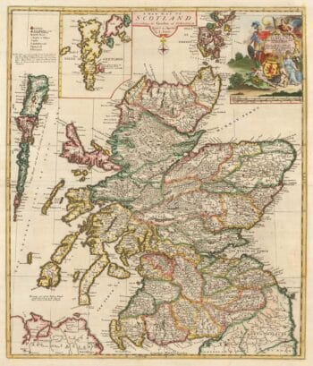
A scarce map of Scotland
£1,000BROWNE, Christopher.
Published In 1721
Stock No. 24436 -

A rare three-sheet prospect of London
£20,000NICHOLLS, Sutton.
Published In 1710
Stock No. 22537 -

Vrients’s scarce map of England, Wales & Ireland
£4,250VRIENTS, Jan Baptist.
Published In 1612
Stock No. 20271 -

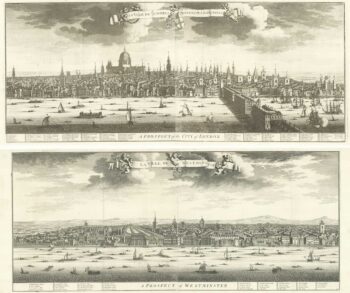
A magnificient pair of early 18th century prospects of London and Westminster
£18,000KIP, Johannes.
Published In 1720
Stock No. 18752 -

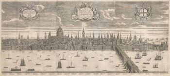
A prospect of Pre-Fire London after Visscher
£3,250DE JONGHE, Clement.
Published In 1660
Stock No. 24489 -

A view of the Battle of Lepanto engraved in 1572
£2,500CAVALIERI, Giovanni Battista de'.
Published In 1647
Stock No. 24486 -

A monumental sea chart of south-west England
£3,250HOOGHE, Romeyn de.
Published In 1693
Stock No. 24483 -

London by one of England’s foremost maritime artists
£7,000WYLLIE, William Lionel.
Published In 1884
Stock No. 24497 -

A very fine early 19th century miniature atlas
£2,250REMONDINI, Giuseppe Antonio.
Published In 1801
Stock No. 24527 -

An instructional card explaining shipboard directions
£220Anonymous.
Published In 1840
Stock No. 24472