Showing 1–12 of 235 results
-

A large and detailed 19th century map of India
£750WALKER, John.
Published In 1829
Stock No. 24543 -

The Peutinger Table, one of the few surviving examples of Roman cartography
£2,000JANSSON, Jan.
Published In 1700
Stock No. 24492 -

A 17th century map of of the Mogol Empire
£700CANTELLI DA VIGNOLA, Giacomo.
Published In 1683
Stock No. 24609 -

16th century Dutch map of Switzerland
£800ORTELIUS, Abraham.
Published In 1575
Stock No. 21809 -

A 16th century woodcut map of Switzerland
£400MUNSTER, Sebastian.
Published In 1572
Stock No. 24570 -

A detailed map of Northern India
£300TARDIEU, Ambroise.
Published In 1780
Stock No. 24559 -

An early 19th century map of India.
£240POIRSON, J.B.
Published In 1803
Stock No. 24554 -

A Victorian map of London illustating the famous buildings
£350SMITH, Charles & Son.
Published In 1871
Stock No. 24520 -

John Oxley’s mapping of New South Wales
£280HALL, Sidney.
Published In 1828
Stock No. 24519 -

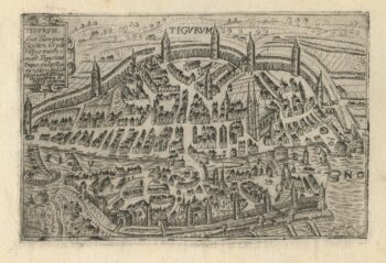
A 16th century town plan of Zurich
£380VALEGIO, Francesco.
Published In 1598
Stock No. 24208 -

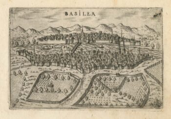
A 16th century town plan of Basle
£280VALEGIO, Francesco.
Published In 1598
Stock No. 24207 -

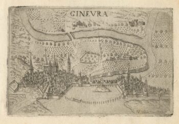
A 16th century town plan of Geneva
£220VALEGIO, Francesco.
Published In 1598
Stock No. 24206