Showing 1–12 of 729 results
-

17th century map of the Sun
£1,850KIRCHER, Athanasius.
Published In 1665
Stock No. 24606 -

An unusual 18th century map of the Holy Land
£800SEUTTER, Matth?us.
Published In 1745
Stock No. 24605 -

A plan of Jerusalem after Adrichom
£750SEUTTER, Matth?us.
Published In 1730
Stock No. 24600 -

16th century woodblock prospect of Lisbon
£450MUNSTER, Sebastian.
Published In 1580
Stock No. 24586 -

An early woodcut map of the Holy Land
£850MUNSTER, Sebastian.
Published In 1552
Stock No. 24569 -

Munster’s classic woodcut map of Italy
£850MUNSTER, Sebastian.
Published In 1572
Stock No. 24562 -

A classic 16th century Dutch map of Italy
£1,400ORTELIUS, Abraham.
Published In 1572
Stock No. 24552 -

17th century prospect of Biblical Jerusalem
£1,000DAPPER, Olfert.
Published In 1677
Stock No. 24540 -

The Peutinger Table, one of the few surviving examples of Roman cartography
£2,000JANSSON, Jan.
Published In 1700
Stock No. 24492 -

16th century map of the Kingdom of Naples
£650ORTELIUS, Abraham.
Published In 1595
Stock No. 24444 -

A 16th century Dutch map of Portugal
£700ORTELIUS, Abraham.
Published In 1595
Stock No. 24408 -

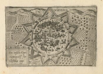
A 16th century town plan of Nicosia
£750VALEGIO, Francesco.
Published In 1598
Stock No. 24176