Showing 1–12 of 436 results
-

17th century map of the Sun
£1,850KIRCHER, Athanasius.
Published In 1665
Stock No. 24606 -

Munster’s classic woodcut map of Italy
£850MUNSTER, Sebastian.
Published In 1572
Stock No. 24562 -

A classic 16th century Dutch map of Italy
£1,400ORTELIUS, Abraham.
Published In 1572
Stock No. 24552 -

16th century map of the Kingdom of Naples
£650ORTELIUS, Abraham.
Published In 1595
Stock No. 24444 -

18th century decorative map of Italy
£550SEUTTER, Matth?us.
Published In 1740
Stock No. 24614 -
A 16th century woodcut prospect of Rome
£400MUNSTER, Sebastian.
Published In 1572
Stock No. 24577 -

A 16th century woodcut map of Classical Rome
£220MUNSTER, Sebastian.
Published In 1572
Stock No. 24572 -

John Oxley’s mapping of New South Wales
£280HALL, Sidney.
Published In 1828
Stock No. 24519 -

A 16th century town plan of Bruges
£240VALEGIO, Francesco.
Published In 1598
Stock No. 24204 -

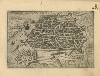
A 16th century town plan of Antwerp
£250VALEGIO, Francesco.
Published In 1598
Stock No. 24203 -

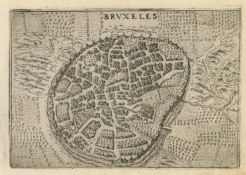
A 16th century town plan of Brussels
£250VALEGIO, Francesco.
Published In 1598
Stock No. 24202 -

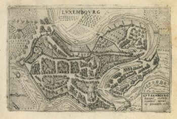
A 16th century town plan of Luxembourg
£300VALEGIO, Francesco.
Published In 1598
Stock No. 24201