Showing 1–12 of 65 results
-

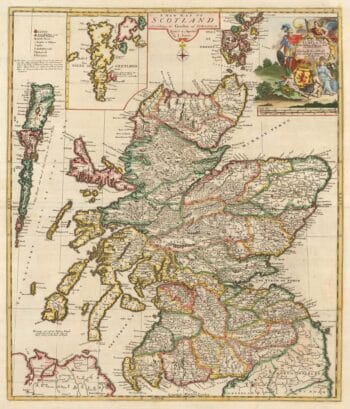
A scarce map of Scotland
£1,000BROWNE, Christopher.
Published In 1721
Stock No. 24436 -

A large scale map of Warwickshire in fine colour
£1,600GREENWOOD, C. & J.
Published In 1822
Stock No. 24068 -

An important 16th century plan of Angra
£2,800LINSCHOTEN, Jan Huygen van.
Published In 1595
Stock No. 23737 -

A large four-sheet map of Midlothian
£750KNOX, James.
Published In 1821
Stock No. 23326 -

A Georgian folding map of Linlithgowshire
£800FORREST, William.
Published In 1818
Stock No. 22680 -

Four scarce Italian playing cards depicting Scotland
£750Anonymous.
Published In 1790
Stock No. 24234 -
The only map by Timothy Pont published in his lifetime
£450PONT, Timothy.
Published In 1638
Stock No. 23842 -

Read’s map of Napoleon’s exile on St Helena, Second State
£1,200READ, R.P.
Published In 1817
Stock No. 22662 -

Napoleon in exile on St Helena
£1,400READ, R.P.
Published In 1815
Stock No. 22661 -

Read’s map of Napoleon’s exile on St Helena, First State
£1,200READ, R.P.
Published In 1815
Stock No. 22660 -

A Dutch map of Scotland in fine original colour
£725JANSSON, Jan.
Published In 1638
Stock No. 23840 -
A classic early map of Scotland in original colour
£1,200ORTELIUS, Abraham.
Published In 1603
Stock No. 23802