- Reset all
- America
- Antarctic
- Atlases
- Azores
- Balearics
- Beijing
- Bolivia
- British Isles Sea Charts
- Buckinghamshire
- Burma
- China
- Cyprus
- Devon
- Florida
- Germany
- Gibraltar
- Globes and Instruments
- Greece
- Gulf States
- Indonesia
- Ionian Islands
- Lancashire
- Latvia and Estonia
- Leicestershire
- London Localities
- Madagascar
- Map Games
- Marche
- Maritime
- Morocco
- New York
- Panama
- Pennsylvania
- Rutland
- Scottish Islands
- Serio-Comic
- Southern Europe
- Suffolk
- Sussex
- Switzerland
- Tuscany
- Ukraine
- Umbria
- World
Showing 25–36 of 1078 results
-

16th century woodblock map of Slovenia and Croatia
£375MUNSTER, Sebastian.
Published In 1572
Stock No. 24581 -

Munster’s map of the Iberian Peninsula
£400MUNSTER, Sebastian.
Published In 1572
Stock No. 24579 -

A 16th century woodcut prospect of Rome
£400MUNSTER, Sebastian.
Published In 1572
Stock No. 24577 -
A 16th century woodcut map of Greece
£380MUNSTER, Sebastian.
Published In 1572
Stock No. 24576 -

A 16th century woodcut map of Classical Rome
£220MUNSTER, Sebastian.
Published In 1572
Stock No. 24572 -
A 16th century woodcut map of Switzerland
£400MUNSTER, Sebastian.
Published In 1572
Stock No. 24570 -
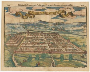
Early decorative birdseye view of Cusco
£380MUNSTER, Sebastian.
Published In 1572
Stock No. 24566 -

An unusual map of South America
£385KIRCHER, Athanasius.
Published In 1678
Stock No. 24560 -

The building of the Uptown Hudson Tubes in New York
£450Anonymous.
Published In 1890
Stock No. 24556 -

18th century map of China
£320TIRION, Isaak.
Published In 1740
Stock No. 24547 -

Vancouver’s mapping of the Pacific North West
£350VANCOUVER, Capt. George.
Published In 1820
Stock No. 24534 -

Seven scarce Italian playing cards depicting the Balkans and Greece
£480Anonymous.
Published In 1790
Stock No. 24361