- Reset all
- America
- Argentina
- Atlases and Books
- Beijing
- Bering Strait
- Bolivia
- Books
- British Islands
- Derbyshire
- Dorset
- French Regions
- Globes and Instruments
- Iceland
- Ionian Islands
- Italy Maps
- Latvia and Estonia
- London
- Middlesex
- Northern Europe
- Pacific and Australasia
- Provence
- Seychelles
- Spain
- Wales
- West Coast
- West Indies
- Wiltshire
- Wind Roses
- World
Showing 25–36 of 786 results
-

A mid-18th century map of North America
£850LOTTER, Tobias Conrad.
Published In 1765
Stock No. 24610 -

A 17th century Dutch map of the West Indies
£1,250VISSCHER, Nicolas.
Published In 1710
Stock No. 24608 -

Nash’s planned layout of Regent Street
£980LUFFMAN, John.
Published In 1814
Stock No. 18274 -

John Nash’s remodelling of St James’s Park
£950MOGG, Edward.
Published In 1827
Stock No. 18193 -

A late-Georgian map of the environs of London
£650CRUCHLEY, George Frederick.
Published In 1827
Stock No. 15495 -

16th century woodblock map of Silesia
£300MUNSTER, Sebastian.
Published In 1572
Stock No. 24582 -

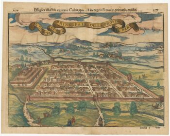
Early decorative birdseye view of Cusco
£380MUNSTER, Sebastian.
Published In 1572
Stock No. 24566 -

An unusual map of South America
£385KIRCHER, Athanasius.
Published In 1678
Stock No. 24560 -

The building of the Uptown Hudson Tubes in New York
£450Anonymous.
Published In 1890
Stock No. 24556 -

Vancouver’s mapping of the Pacific North West
£350VANCOUVER, Capt. George.
Published In 1820
Stock No. 24534 -

A Victorian map of London illustating the famous buildings
£350SMITH, Charles & Son.
Published In 1871
Stock No. 24520 -

John Oxley’s mapping of New South Wales
£280HALL, Sidney.
Published In 1828
Stock No. 24519