- Reset all
- America
- Argentina
- Atlases and Books
- Beijing
- Bering Strait
- Bolivia
- Books
- British Isles Sea Charts
- Derbyshire
- Dorset
- Falklands
- French Regions
- Grenada
- Iceland
- Italy Maps
- Latvia and Estonia
- London
- Middlesex
- New York
- North Africa
- Northern Europe
- Prospects
- Spain
- Ukraine
- Wales
- West Coast
- West Indies
- Wind Roses
- World
Showing 37–48 of 691 results
-

A ‘bird’s-eye’ map of the Gordon Relief Mission, 1884
£1,750BACON, George Washington.
Published In 1885
Stock No. 24107 -

A highly decorative separate-issue world map
£4,500BAILLEUL, Nicolas (le Jeune).
Published In 1750
Stock No. 24097 -

A rare Italian edition of Hennepin’s landmark map of Louisiana
£2,800HENNEPIN, Louis.
Published In 1691
Stock No. 24027 -

A very scarce handkerchief map of London
£2,800Anonymous.
Published In 1832
Stock No. 20799 -

An 18th century two-sheet plan of London
£3,800FOSTER, George.
Published In 1778
Stock No. 18487 -

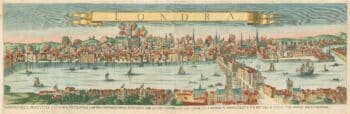
A prospect of the Great Fire of London
£5,000GUALDO PRIORATO, Gabriel.
Published In 1675
Stock No. 17875 -

The Colombian Canal, an alternative scheme to Panama
£1,600PUYDT, Lucien de.
Published In 1871
Stock No. 24108 -

The famous 17th century map of Italy by John Speed
£2,500SPEED, John.
Published In 1665
Stock No. 23988 -

A late 18th century wall map of the world on four sheets
£6,000DUNN, Samuel.
Published In 1799
Stock No. 23965 -

A Victorian plan of London
£750WYLD, James.
Published In 1859
Stock No. 23945 -

A 17th century Dutch World map with superb decorative borders
£5,500DE WIT, Frederick.
Published In 1670
Stock No. 23590 -

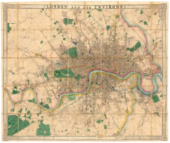
A fine 19th century wall map of London
£4,800WYLD, James.
Published In 1875
Stock No. 23579