- Reset all
- Andalusia
- Antarctic
- Antigua
- Benelux
- Bohemia
- Caspian Sea
- Central America
- China
- Falklands
- Hertfordshire
- Holy Land
- Indian Ocean
- Latvia and Estonia
- Liguria
- Luxembourg
- Monaco
- New York
- North Africa
- Northern Italy
- Patagonia
- Sardinia
- Scandinavia
- Scientific Instruments
- Scottish Islands
- Singapore
- Texas
- Trentino
- West Indies
- Western Europe
Showing 13–24 of 654 results
-

Ortelius’s map of Barbary in fine colour
£600ORTELIUS, Abraham.
Published In 1603
Stock No. 23807 -

A 17th century Dutch map of the West Indies
£1,250VISSCHER, Nicolas.
Published In 1710
Stock No. 24608 -

16th century Dutch map of Switzerland
£800ORTELIUS, Abraham.
Published In 1575
Stock No. 21809 -

16th century woodblock map of France
£380MUNSTER, Sebastian.
Published In 1572
Stock No. 24580 -

A 16th century woodcut map of Switzerland
£400MUNSTER, Sebastian.
Published In 1572
Stock No. 24570 -

18th century map of China
£320TIRION, Isaak.
Published In 1740
Stock No. 24547 -

A scarce map of the Holy Land in the 18th century
£250FER, Nicolas de.
Published In 1707
Stock No. 24525 -

A scarce map of the Holy Land in Biblical times
£250FER, Nicolas de.
Published In 1707
Stock No. 24524 -

The uncommon Spanish edition of Blaeu’s map of Hertfordshire
£450BLAEU, Johannes.
Published In 1662
Stock No. 24521 -

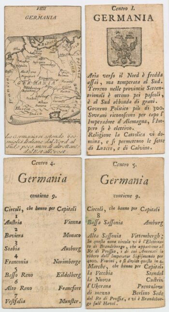
Four scarce Italian playing cards depicting Germany
£280Anonymous.
Published In 1790
Stock No. 24244 -

A 16th century town plan of Tangier
£220VALEGIO, Francesco.
Published In 1598
Stock No. 24217 -

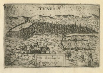
A 16th century town plan of Tunis
£160VALEGIO, Francesco.
Published In 1598
Stock No. 24216