Showing 13–24 of 438 results
-

The map of China from the first English atlas of the world
£3,700SPEED, John.
Published In 1665
Stock No. 23978 -

19th century Spanish sea chart of the Yellow Sea and Korea
£2,200BRYANT, Tomas.
Published In 1866
Stock No. 12450 -

The Colombian Canal, an alternative scheme to Panama
£1,600PUYDT, Lucien de.
Published In 1871
Stock No. 24108 -

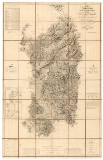
An important 19th century map of Sardinia
£1,100Alberto., Alberto., FERRERO DELLA MARMORA
Published In 1845
Stock No. 24225 -

A 19th century American sea chart of Hong Kong
£3,500BREWER, H.G.
Published In 1916
Stock No. 23973 -

The most important prospect of Brescia
£18,000CARBONI, Domenico.
Published In 1764
Stock No. 23648 -

A detailed map of Victoria in the 1930s
£4,500WAR OFFICE.
Published In 1930
Stock No. 23458 -

An impressive 16th century two-sheet plan of Antwerp
£1,500HOEFNAGEL, Joris.
Published In 1596
Stock No. 23372 -

The peregrinations of Abraham
£2,000ORTELIUS, Abraham.
Published In 1603
Stock No. 24384 -

A magnificent map of Liguria in superb original colour
£6,000VRIENTS, Jan Baptist.
Published In 1608
Stock No. 24382 -

Five scarce Italian playing cards depicting Sweden and the Baltic
£700Anonymous.
Published In 1790
Stock No. 24237 -

Decorative 18th century map of Norway
£460HOMANN, Johann Baptist.
Published In 1720
Stock No. 24171