Showing 1–12 of 263 results
-

A geological map of the Duchy of Tyrol
£2,350STOTTER, Michael.
Published In 1851
Stock No. 23050 -

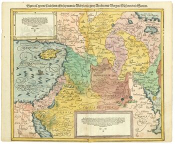
16th century map of the Eastern Mediterranean in rare early colour
£880MUNSTER, Sebastian.
Published In 1550
Stock No. 24441 -

A rare wall map of the Holy Land
£9,000NOLIN, Jean Baptiste.
Published In 1785
Stock No. 24500 -

An incunable prospect of Jerusalem
£1,600SCHEDEL, D. Hartmann.
Published In 1493
Stock No. 24425 -

Russia, from the first English atlas of the World
£2,200SPEED, John.
Published In 1676
Stock No. 23731 -

A 16th century map of the colony of New Spain
£750ORTELIUS, Abraham.
Published In 1584
Stock No. 24448 -

The founding of St Petersburg by Peter the Great
£700ZATTA, Antonio.
Published In 1797
Stock No. 24504 -

An early 20th century plaster relief map of Jerusalem in a box
£1,200VESTER, Frederick.
Published In 1910
Stock No. 24365 -

The Colombian Canal, an alternative scheme to Panama
£1,600PUYDT, Lucien de.
Published In 1871
Stock No. 24108 -

The most important prospect of Brescia
£18,000CARBONI, Domenico.
Published In 1764
Stock No. 23648 -

An impressive 16th century two-sheet plan of Antwerp
£1,500HOEFNAGEL, Joris.
Published In 1596
Stock No. 23372 -

Detailed folding map of the ‘Patriotic War of 1812’
£550VALLARDI, Guiseppe and Pietro.
Published In 1808
Stock No. 22675