- Reset all
- Antarctic
- Argentina
- Atlases
- Australia
- Azores
- Balearics
- Beijing
- Bolivia
- British Isles Sea Charts
- Buckinghamshire
- China
- Cumberland
- Cyprus
- Devon
- Europe Continent
- Florida
- Germany
- Greece
- Grenada
- Gulf States
- Indian Ocean
- Indonesia
- Ionian Islands
- Lancashire
- Latvia and Estonia
- London Localities
- London Transport Maps
- Madagascar
- Marche
- Maritime
- Morocco
- New York
- Panama
- Pennsylvania
- Rutland
- Scottish Islands
- Serio-Comic
- Shropshire
- Sicily
- Sussex
- Sweden
- Switzerland
- Tuscany
- Umbria
- World
Showing 1–12 of 626 results
-

Munster’s famous ‘Upside-down’ map of Europe
£1,350MUNSTER, Sebastian.
Published In 1572
Stock No. 24568 -

The English edition of Du Halde’s map of Guangdong
£1,600DU HALDE, Johann Baptiste.
Published In 1738
Stock No. 24558 -

A late Victorian plan of Brighton.
£1,100TREACHER, H. & C.
Published In 1890
Stock No. 24546 -

A detailed plan of Kensington Gardens and Hyde Park
£750ORDNANCE SURVEY.
Published In 1906
Stock No. 24529 -

A map illustrating the British dominance of the seas
£450LONDON GEOGRAPHICAL INSTITUTE.
Published In 1922
Stock No. 24508 -

The Peutinger Table, one of the few surviving examples of Roman cartography
£2,000JANSSON, Jan.
Published In 1700
Stock No. 24492 -

Magini’s edition of Ptolemy’s Geography
£6,000MAGINI, Giovanni Antonio.
Published In 1598
Stock No. 24449 -

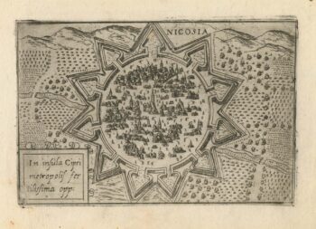
A 16th century town plan of Nicosia
£750VALEGIO, Francesco.
Published In 1598
Stock No. 24176 -

A rare 16th century Italian plan of Famagusta
£950VALEGIO, Francesco.
Published In 1598
Stock No. 24148 -

The First Issue of the iconic map of the London Underground, with overprinting
£2,600BECK, Henry C.
Published In 1933
Stock No. 24422 -

A miniature double-hemisphere world.
£600SANSON, Nicolas.
Published In 1735
Stock No. 22316 -

16th century Dutch map of Switzerland
£800ORTELIUS, Abraham.
Published In 1575
Stock No. 21809