- Reset all
- Antarctic
- Argentina
- Atlases
- Azores
- Balearics
- Bolivia
- British Isles Sea Charts
- Buckinghamshire
- Burma
- Central Africa
- China
- Cyprus
- Devon
- Florida
- Germany
- Gibraltar
- Greece
- Gulf States
- Indian Ocean
- Indonesia
- Ionian Islands
- Lancashire
- Latvia and Estonia
- London Localities
- London Transport Maps
- Madagascar
- Map Games
- Marche
- Maritime
- Morocco
- New York
- Panama
- Pennsylvania
- Prospects
- Rutland
- Scottish Islands
- Serio-Comic
- Sicily
- South Africa
- Southern Europe
- Suffolk
- Sussex
- Switzerland
- Tuscany
- Ukraine
- Umbria
- World
Showing 1–12 of 904 results
-

A geological map of the Duchy of Tyrol
£2,350STOTTER, Michael.
Published In 1851
Stock No. 23050 -

Ortelius’s pocket atlas with the Galle maps in fine colour
£14,000ORTELIUS, Abraham.
Published In 1595
Stock No. 24476 -

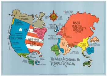
A serio-comic map satirising Ronald Reagan’s view of the World
£650HORSEY, David.
Published In 1984
Stock No. 24474 -

A Victorian game map of the world.
£5,500JONES, Thomas Henry.
Published In 1845
Stock No. 24423 -

Ruysch’s 1507 world map, with the earliest obtainable depiction of the Americas
£260,000RUYSCH, Johann.
Published In 1507
Stock No. 22807 -

A rare three-sheet prospect of London
£20,000NICHOLLS, Sutton.
Published In 1710
Stock No. 22537 -

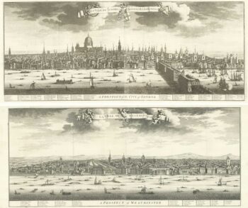
A magnificient pair of early 18th century prospects of London and Westminster
£18,000KIP, Johannes.
Published In 1720
Stock No. 18752 -

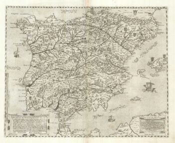
A two-sheet ‘Lafreri-School’ important map of Iberia
£9,750FORLANI, Paolo.
Published In 1567
Stock No. 24477 -

A 17th century chart of the eastern Mediterranean in fine colour.
£1,600DE WIT, Frederick.
Published In 1745
Stock No. 24490 -

A prospect of Pre-Fire London after Visscher
£3,250DE JONGHE, Clement.
Published In 1660
Stock No. 24489 -

de Hooghe’s spectacular chart of the Mediterranean Sea
£36,500HOOGHE, Romeyn de.
Published In 1694
Stock No. 24488 -

A view of the Battle of Lepanto engraved in 1572
£2,500CAVALIERI, Giovanni Battista de'.
Published In 1647
Stock No. 24486