- Reset all
- Antarctic
- Argentina
- Atlases
- Bering Strait
- Bristol
- Canary Islands
- Eastern Europe
- Hertfordshire
- Holy Land
- Hong Kong
- Lancashire
- Latvia and Estonia
- Morocco
- Netherlands
- North America Maps
- Northamptonshire
- Nottinghamshire
- Solar System
- South Africa
- United States
- Vietnam
- Westmorland
- World and Continents
Showing 1–12 of 317 results
-

Ortelius’s pocket atlas with the Galle maps in fine colour
£14,000ORTELIUS, Abraham.
Published In 1595
Stock No. 24476 -
16th century map of the Eastern Mediterranean in rare early colour
£880MUNSTER, Sebastian.
Published In 1550
Stock No. 24441 -

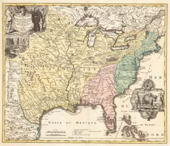
‘The Buffalo map’ of the Mississippi
£2,000HOMANN, Johann Baptist.
Published In 1720
Stock No. 24427 -

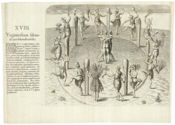
The famous scene the Virginians’ Manner of Dancing at their Religious Festivals
£1,900WHITE, John.
Published In 1619
Stock No. 24424 -

A rare wall map of the Holy Land
£9,000NOLIN, Jean Baptiste.
Published In 1785
Stock No. 24500 -

A very fine early 19th century miniature atlas
£2,250REMONDINI, Giuseppe Antonio.
Published In 1801
Stock No. 24527 -

An advert for an American railway
£750Anonymous.
Published In 1865
Stock No. 24455 -

An incunable prospect of Jerusalem
£1,600SCHEDEL, D. Hartmann.
Published In 1493
Stock No. 24425 -

A two-sheet map of North America
£2,950JAILLOT, Alexis-Hubert.
Published In 1705
Stock No. 24062 -

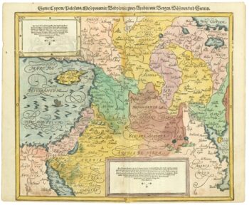
Russia, from the first English atlas of the World
£2,200SPEED, John.
Published In 1676
Stock No. 23731 -

A two-sheet map of North America
£2,250JAILLOT, Alexis-Hubert.
Published In 1674
Stock No. 24482 -

The founding of St Petersburg by Peter the Great
£700ZATTA, Antonio.
Published In 1797
Stock No. 24504