- Reset all
- Antarctic
- Argentina
- Austria
- Bering Strait
- Bristol
- Canary Islands
- Eastern Europe
- Georgia
- Hertfordshire
- Holy Land
- Hungary
- Lancashire
- Latvia and Estonia
- London Transport Maps
- Morocco
- Netherlands
- North America Maps
- Northamptonshire
- Nottinghamshire
- Old World
- Oxfordshire
- Peru
- Solar System
- St Lucia
- United States
- Vietnam
- Westmorland
- World and Continents
Showing 1–12 of 350 results
-

17th century map of the Sun
£1,850KIRCHER, Athanasius.
Published In 1665
Stock No. 24606 -

An unusual 18th century map of the Holy Land
£800SEUTTER, Matth?us.
Published In 1745
Stock No. 24605 -

A plan of Jerusalem after Adrichom
£750SEUTTER, Matth?us.
Published In 1730
Stock No. 24600 -

An early woodcut map of the Holy Land
£850MUNSTER, Sebastian.
Published In 1552
Stock No. 24569 -

18th century map of the Eastern Seaboard
£750ROBERT DE VAUGONDY, Didier.
Published In 1770
Stock No. 24555 -

An 18th century map of North America
£1,200WEIGEL, Christoph.
Published In 1718
Stock No. 24541 -

The Peutinger Table, one of the few surviving examples of Roman cartography
£2,000JANSSON, Jan.
Published In 1700
Stock No. 24492 -

A 16th century Italian plan of Buda
£600VALEGIO, Francesco.
Published In 1598
Stock No. 24150 -

The First Issue of the iconic map of the London Underground, with overprinting
£2,600BECK, Henry C.
Published In 1933
Stock No. 24422 -

A mid-18th century map of North America
£850LOTTER, Tobias Conrad.
Published In 1765
Stock No. 24610 -

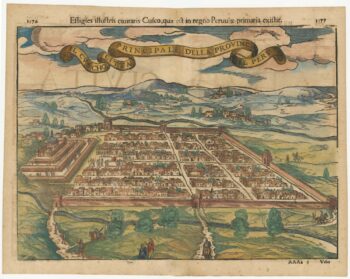
Early decorative birdseye view of Cusco
£380MUNSTER, Sebastian.
Published In 1572
Stock No. 24566 -

The building of the Uptown Hudson Tubes in New York
£450Anonymous.
Published In 1890
Stock No. 24556