- Reset all
- Antarctic
- Argentina
- Austria
- Bering Strait
- Bristol
- Canary Islands
- Eastern Europe
- Georgia
- Hertfordshire
- Holy Land
- Hungary
- Lancashire
- Latvia and Estonia
- London Transport Maps
- Morocco
- Netherlands
- North America Maps
- Northamptonshire
- Nottinghamshire
- Old World
- Oxfordshire
- Solar System
- St Lucia
- United States
- Vietnam
- Westmorland
- World and Continents
Showing 13–24 of 343 results
-

A scarce map of the Holy Land in the 18th century
£250FER, Nicolas de.
Published In 1707
Stock No. 24525 -

A scarce map of the Holy Land in Biblical times
£250FER, Nicolas de.
Published In 1707
Stock No. 24524 -

The uncommon Spanish edition of Blaeu’s map of Hertfordshire
£450BLAEU, Johannes.
Published In 1662
Stock No. 24521 -

Seven scarce Italian playing cards depicting Russia
£480Anonymous.
Published In 1790
Stock No. 24360 -

A 16th century town plan of Tangier
£220VALEGIO, Francesco.
Published In 1598
Stock No. 24217 -

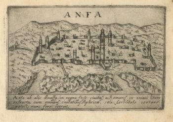
A 16th century town plan of Casablanca
£240VALEGIO, Francesco.
Published In 1598
Stock No. 24215 -

A 16th century town plan of Vienna
£200VALEGIO, Francesco.
Published In 1598
Stock No. 24172 -

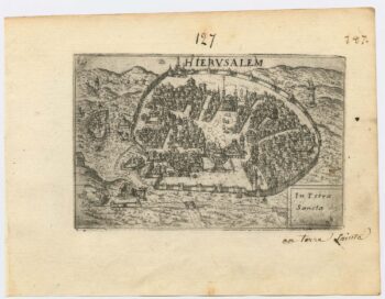
A 16th century town plan of Jerusalem
£450VALEGIO, Francesco.
Published In 1598
Stock No. 24161 -

16th century map of the Eastern Mediterranean in rare early colour
£880MUNSTER, Sebastian.
Published In 1550
Stock No. 24441 -

‘The Buffalo map’ of the Mississippi
£2,000HOMANN, Johann Baptist.
Published In 1720
Stock No. 24427 -

The famous scene the Virginians’ Manner of Dancing at their Religious Festivals
£1,900WHITE, John.
Published In 1619
Stock No. 24424 -

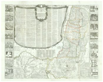
A rare wall map of the Holy Land
£9,000NOLIN, Jean Baptiste.
Published In 1785
Stock No. 24500