- Reset all
- Antarctic
- Atlases
- Azores
- Balearics
- Bolivia
- British Isles Sea Charts
- Buckinghamshire
- Burma
- China
- Cyprus
- Devon
- Florida
- Germany
- Gibraltar
- Globes and Instruments
- Greece
- Gulf States
- Indian Ocean
- Indochina
- Indonesia
- Ionian Islands
- Lancashire
- Latvia and Estonia
- London Localities
- Madagascar
- Map Games
- Marche
- Maritime
- Morocco
- New York
- Nottinghamshire
- Panama
- Pennsylvania
- Pictorial Maps
- Rutland
- Scottish Islands
- Serio-Comic
- Suffolk
- Sussex
- Switzerland
- Tuscany
- Ukraine
- Umbria
- World
Showing 1–12 of 586 results
-

Ortelius’s pocket atlas with the Galle maps in fine colour
£14,000ORTELIUS, Abraham.
Published In 1595
Stock No. 24476 -

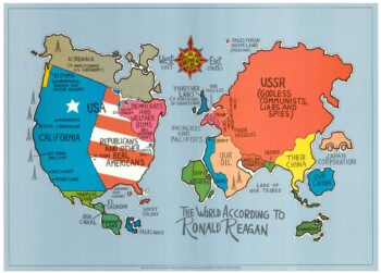
A serio-comic map satirising Ronald Reagan’s view of the World
£650HORSEY, David.
Published In 1984
Stock No. 24474 -

A rare lunar relief globe celebrating man reaching the Moon
£3,000WIGHTMAN, A. J.
Published In 1969
Stock No. 24470 -

A Victorian game map of the world.
£5,500JONES, Thomas Henry.
Published In 1845
Stock No. 24423 -

Ruysch’s 1507 world map, with the earliest obtainable depiction of the Americas
£260,000RUYSCH, Johann.
Published In 1507
Stock No. 22807 -

A view of the Battle of Lepanto engraved in 1572
£2,500CAVALIERI, Giovanni Battista de'.
Published In 1647
Stock No. 24486 -

A monumental sea chart of south-west England
£3,250HOOGHE, Romeyn de.
Published In 1693
Stock No. 24483 -
Uncommon 16th century Italian map of Cyprus
£1,600ROSACCIO, Giuseppe.
Published In 1598
Stock No. 24538 -

A monumental 18th century wall map of Switzerland on four sheets
£6,500SCHEUCHZER, Johann Jakob.
Published In 1712
Stock No. 24499 -

One of the earliest world maps available to the collector
£15,000SCHEDEL, D. Hartmann.
Published In 1493
Stock No. 24528 -

A very fine early 19th century miniature atlas
£2,250REMONDINI, Giuseppe Antonio.
Published In 1801
Stock No. 24527 -

An instructional card explaining shipboard directions
£220Anonymous.
Published In 1840
Stock No. 24472