Showing 1–12 of 35 results
-

A pictorial map of Beijing in the 1930s
£3,000DORN, Frank.
Published In 1936
Stock No. 24392 -

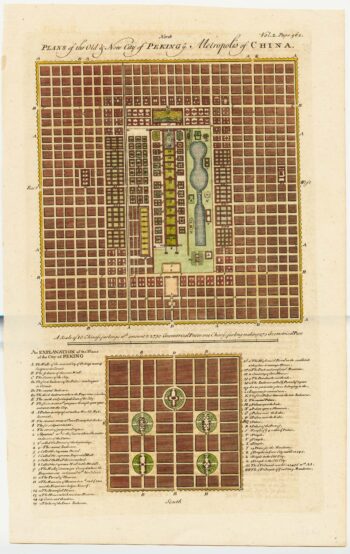
18th century town plan of Peking
£450HARRIS, John.
Published In 1748
Stock No. 23674 -

Mid 19th century map of Tibet, Mongolia and Manchuria
£160TALLIS, John.
Published In 1851
Stock No. 21614 -

The famous Ortelius map of the northern Atlantic regions
£2,250ORTELIUS, Abraham.
Published In 1612
Stock No. 22499 -

An early chart of Monterey Bay
£400LA PEROUSE, Jean-Francois de Galaup de.
Published In 1797
Stock No. 22414 -

Early charts of San Diego and San Blas
£340LA PEROUSE, Jean-Francois de Galaup de.
Published In 1797
Stock No. 22412 -

A 16th century miniature map of Cuba
£280LANGENES, Barent.
Published In 1599
Stock No. 21259 -

The map of Tahiti from Cook’s First Voyage
£250COOK, James.
Published In 1773
Stock No. 20890 -

A 17th century map of Northern Puglia and Gargano area
£360JANSSON, Jan.
Published In 1647
Stock No. 20845 -

The arrival of the VOC Embassy at Beijing
£550NIEUHOFF, Johan.
Published In 1671
Stock No. 20696 -

Cuba, during the Seven Years’ War
£350RASPE, Gabriel Nikolaus.
Published In 1763
Stock No. 20680 -

Cuba from an account of the voyages of Columbus
£350AA, Pieter van der.
Published In 1707
Stock No. 20645