Showing 1–12 of 411 results
-

Ortelius’s pocket atlas with the Galle maps in fine colour
£14,000ORTELIUS, Abraham.
Published In 1595
Stock No. 24476 -

A rare two volume geographical lexicon
£17,500LASOR A VAREA, Alphonsus.
Published In 1713
Stock No. 24516 -

A monumental 18th century wall map of Switzerland on four sheets
£6,500SCHEUCHZER, Johann Jakob.
Published In 1712
Stock No. 24499 -

A very fine early 19th century miniature atlas
£2,250REMONDINI, Giuseppe Antonio.
Published In 1801
Stock No. 24527 -

17th century map of Arabia
£1,000MEURS, Jacob van.
Published In 1680
Stock No. 20175 -

A late-18th century plan of Geneva
£250ANDREWS, John.
Published In 1800
Stock No. 24514 -

A late-18th century plan of Berlin
£260ANDREWS, John.
Published In 1800
Stock No. 24513 -

Chart of the Planetary System
£175BLUNT, Charles F.
Published In 1845
Stock No. 24250 -

A biography of Pope Pius V with a folding plate of the Battle of Lepanto
£3,000CATENA, Girolamo.
Published In 1647
Stock No. 24340 -

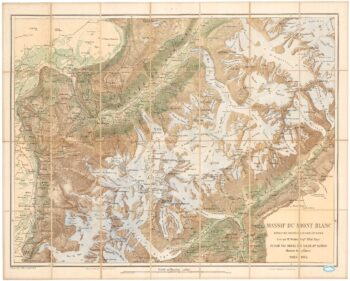
A detailed plan of the Mont-Blanc massif
£1,600BARBEY, Albert.
Published In 1924
Stock No. 22980 -

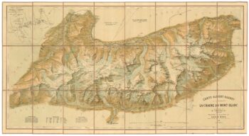
An important map of the Mont Blanc Massif
£950MIEULET, Jean-Joseph.
Published In 1865
Stock No. 24076 -

A 17th century sea chart of the Gulf of Aden in Dudley’s unique style
£3,250DUDLEY, Robert.
Published In 1646
Stock No. 23592