Showing 1–12 of 128 results
-

A late Victorian plan of Brighton.
£1,100TREACHER, H. & C.
Published In 1890
Stock No. 24546 -

A map illustrating the British dominance of the seas
£450LONDON GEOGRAPHICAL INSTITUTE.
Published In 1922
Stock No. 24508 -

The Peutinger Table, one of the few surviving examples of Roman cartography
£2,000JANSSON, Jan.
Published In 1700
Stock No. 24492 -

A miniature double-hemisphere world.
£600SANSON, Nicolas.
Published In 1735
Stock No. 22316 -

Chart of the Zodiac sign Cancer
£275BLUNT, Charles F.
Published In 1845
Stock No. 24288 -

A 16th century Italian plan of Aden
£240VALEGIO, Francesco.
Published In 1598
Stock No. 24139 -

A serio-comic map satirising Ronald Reagan’s view of the World
£650HORSEY, David.
Published In 1984
Stock No. 24474 -

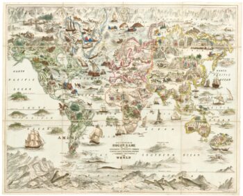
A Victorian game map of the world.
£5,500JONES, Thomas Henry.
Published In 1845
Stock No. 24423 -

Ruysch’s 1507 world map, with the earliest obtainable depiction of the Americas
£260,000RUYSCH, Johann.
Published In 1507
Stock No. 22807 -

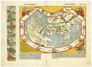
One of the earliest world maps available to the collector
£15,000SCHEDEL, D. Hartmann.
Published In 1493
Stock No. 24528 -
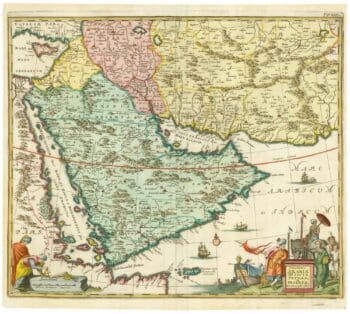
17th century map of Arabia
£1,000MEURS, Jacob van.
Published In 1680
Stock No. 20175 -

A large scale map of Sussex in fine colour
£2,800GREENWOOD, C. & J.
Published In 1825
Stock No. 24224