- Reset all
- Argentina
- Asia Continent
- Bering Strait
- Bolivia
- British Isles Sea Charts
- Campania
- Canada
- Canary Islands
- Cuba
- Devon
- Eastern Europe
- Eastern Seaboard Maps
- Elba
- Georgia
- Gulf States
- Hertfordshire
- Lancashire
- Latvia and Estonia
- Madeira
- Maritime
- Miscellany
- Morocco
- Netherlands
- Northamptonshire
- Nottinghamshire
- Pacific Ocean
- Prints
- Russia
- Scotland Maps
- Scottish Islands
- Singapore
- Solar System
- St Petersburg
- Switzerland
- Trentino
- United States
- Vietnam
- Virginia
- Westmorland
- World and Continents
- World Maps
Showing 37–48 of 500 results
-

A two-sheet, double-hemisphere world map full of unusual features
£16,000MORTIER, Pierre.
Published In 1700
Stock No. 24058 -

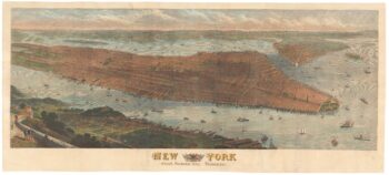
A highly-detailed prospect of Manhattan
£3,500SULMAN, Thomas.
Published In 1876
Stock No. 23720 -

An 18th century two-sheet sea chart of the English Channel based on Halley
£1,250MOUNT & PAGE.
Published In 1745
Stock No. 23424 -

The British Empire at its height
£950GROSS, Alexander.
Published In 1920
Stock No. 23375 -

Detailed folding map of the ‘Patriotic War of 1812’
£550VALLARDI, Guiseppe and Pietro.
Published In 1808
Stock No. 22675 -

Detailed folding map of the ‘Patriotic War of 1812’
£960SUKHTELEN & OPPERMAN.
Published In 1808
Stock No. 22673 -

Detailed early 19th century folding map of Russia
£600NANTIAT, Jasper.
Published In 1808
Stock No. 22670 -

The title page to a sea atlas in superb colour
£1,200HOOGHE, Romeyn de.
Published In 1693
Stock No. 24410 -

The largest representation of Hawaii to appear in an atlas
£900VANDERMAELEN, Philippe.
Published In 1827
Stock No. 24396 -

A plan of Geneva with contemporary manuscript for the Revolution of 1782
£2,500GLOT, C.B.
Published In 1777
Stock No. 24391 -

The iconic depiction of the Copernican solar system
£5,000CELLARIUS, Andreas.
Published In 1708
Stock No. 24383 -
An uncommon Italian map of the western United States
£450MARMOCCHI, Francesco C.
Published In 1858
Stock No. 24374