- Reset all
- Argentina
- Baltic Sea
- Bering Strait
- Bolivia
- British Isles
- Canada
- Canary Islands
- Central Asia
- Devon
- Dorset
- Eastern Europe
- Eastern Seaboard Maps
- Ecuador
- Elba
- Georgia
- Gulf States
- Hertfordshire
- Lancashire
- Latvia and Estonia
- Madeira
- Maritime
- Mauritius and Reunion
- Middlesex
- Morocco
- Near East
- Netherlands
- North America Maps
- Northamptonshire
- Nottinghamshire
- Prints
- Russia
- Scottish Islands
- St Petersburg
- Surrey
- Switzerland
- Trentino
- United States
- Vietnam
- Virginia
- Westmorland
- World and Continents
- World Maps
Showing 13–24 of 892 results
-

A miniature double-hemisphere world.
£600SANSON, Nicolas.
Published In 1735
Stock No. 22316 -

A mid-18th century map of North America
£850LOTTER, Tobias Conrad.
Published In 1765
Stock No. 24610 -

A 17th century map of of the Mogol Empire
£700CANTELLI DA VIGNOLA, Giacomo.
Published In 1683
Stock No. 24609 -

16th century Dutch map of Switzerland
£800ORTELIUS, Abraham.
Published In 1575
Stock No. 21809 -

A 16th century woodcut map of Switzerland
£400MUNSTER, Sebastian.
Published In 1572
Stock No. 24570 -

A detailed map of Northern India
£300TARDIEU, Ambroise.
Published In 1780
Stock No. 24559 -

The building of the Uptown Hudson Tubes in New York
£450Anonymous.
Published In 1890
Stock No. 24556 -

An early 19th century map of India.
£240POIRSON, J.B.
Published In 1803
Stock No. 24554 -

An early 18th century map of the Middle East
£450CHATELAIN, Henri Abraham.
Published In 1720
Stock No. 24551 -

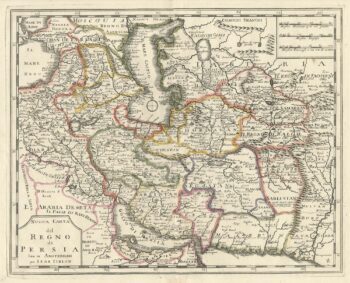
An 18th century Italian map of Persia
£300TIRION, Isaak.
Published In 1740
Stock No. 24550 -
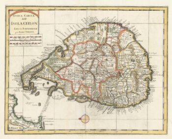
18th century map of Sri Lanka
£260TIRION, Isaak.
Published In 1740
Stock No. 24548 -

Vancouver’s mapping of the Pacific North West
£350VANCOUVER, Capt. George.
Published In 1820
Stock No. 24534