- Reset all
- Argentina
- Belgium
- Bering Strait
- Canary Islands
- Cape Verde Islands
- Eastern Europe
- Georgia
- Hertfordshire
- Holy Land
- Lancashire
- Latvia and Estonia
- Lincolnshire
- London Environs
- Madeira
- Morocco
- Netherlands
- North Africa
- North America Maps
- Northamptonshire
- Nottinghamshire
- Russia
- Solar System
- Southern Europe
- United States
- Vietnam
- Westmorland
- World and Continents
- World Maps
Showing 1–12 of 848 results
-

A geological map of the Duchy of Tyrol
£2,350STOTTER, Michael.
Published In 1851
Stock No. 23050 -

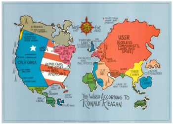
A serio-comic map satirising Ronald Reagan’s view of the World
£650HORSEY, David.
Published In 1984
Stock No. 24474 -
16th century map of the Eastern Mediterranean in rare early colour
£880MUNSTER, Sebastian.
Published In 1550
Stock No. 24441 -

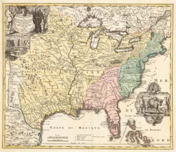
‘The Buffalo map’ of the Mississippi
£2,000HOMANN, Johann Baptist.
Published In 1720
Stock No. 24427 -

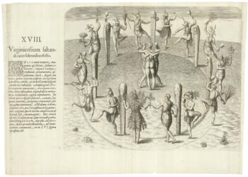
The famous scene the Virginians’ Manner of Dancing at their Religious Festivals
£1,900WHITE, John.
Published In 1619
Stock No. 24424 -

A Victorian game map of the world.
£5,500JONES, Thomas Henry.
Published In 1845
Stock No. 24423 -

Ruysch’s 1507 world map, with the earliest obtainable depiction of the Americas
£260,000RUYSCH, Johann.
Published In 1507
Stock No. 22807 -

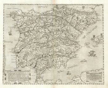
A two-sheet ‘Lafreri-School’ important map of Iberia
£9,750FORLANI, Paolo.
Published In 1567
Stock No. 24477 -

A 17th century chart of the eastern Mediterranean in fine colour.
£1,600DE WIT, Frederick.
Published In 1745
Stock No. 24490 -

de Hooghe’s spectacular chart of the Mediterranean Sea
£36,500HOOGHE, Romeyn de.
Published In 1694
Stock No. 24488 -
Uncommon 16th century Italian map of Cyprus
£1,600ROSACCIO, Giuseppe.
Published In 1598
Stock No. 24538 -

A rare lifetime printing of Blaeu’s view of Vesuvius erupting in 1631
£1,400BLAEU, Johannes.
Published In 1663
Stock No. 24506