- Reset all
- Argentina
- Bering Strait
- Burma
- Canada
- Canary Islands
- Central America
- Devon
- Eastern Europe
- Elba
- Far East Maps
- France
- Georgia
- Gloucestershire
- Gulf States
- Hertfordshire
- Holy Land
- Italian Islands
- Lancashire
- Latvia and Estonia
- Leinster
- Madeira
- Morocco
- Netherlands
- North America Maps
- Northamptonshire
- Nottinghamshire
- Prints
- Russia
- Solar System
- St Helena
- Surrey
- Tartary
- Trentino
- Ukraine
- United States
- Vietnam
- Westmorland
- World and Continents
- World Maps
Showing 601–612 of 620 results
-

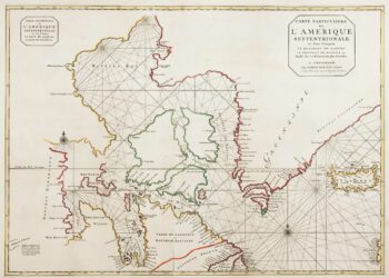
18th century map of the American South East
£500SANTINI, Francesco & Paolo.
Published In 1776
Stock No. 9346 -

Large and detailed 18th century map of Sardinia
£750SEUTTER, Matthaus.
Published In 1730
Stock No. 9318 -

The so-called ‘Anonymous’ map of Surrey
£2,000SMITH, William.
Published In 1665
Stock No. 9177 -

Miniature map of Sardinia
£155ORTELIUS, Abraham.
Published In 1602
Stock No. 9144 -

Miniature map of Corsica
£125ORTELIUS, Abraham.
Published In 1602
Stock No. 9121 -

Holland
£400QUAD, Matthias.
Published In 1600
Stock No. 9094 -

Plan of Toulon in the mid-19th century
£75Society for the Diffusion of Useful Knowledge.
Published In 1836
Stock No. 9047 -
Map of France celebrating the military successes of Louis XIV
£450LOTTER, Tobias Conrad.
Published In 1750
Stock No. 8717 -

Blue-Back Chart of the Bay of Biscay
£650STEEL & CO.
Published In 1813
Stock No. 9661 -

French Post Roads
£280LOTTER, Tobias Conrad.
Published In 1750
Stock No. 8713 -

The search for the North West Passage
£700MORTIER, Pierre.
Published In 1705
Stock No. 8709 -

A two-sheet map of France
£700JAILLOT, Alexis-Hubert.
Published In 1705
Stock No. 8440