Showing 1–12 of 43 results
-

Ortelius’s pocket atlas with the Galle maps in fine colour
£14,000ORTELIUS, Abraham.
Published In 1595
Stock No. 24476 -

A rare two volume geographical lexicon
£17,500LASOR A VAREA, Alphonsus.
Published In 1713
Stock No. 24516 -

A very fine early 19th century miniature atlas
£2,250REMONDINI, Giuseppe Antonio.
Published In 1801
Stock No. 24527 -

A serio-comic map of Europe with the Russian octopus
£4,750GROSSI, Augusto.
Published In 1878
Stock No. 24393 -

A biography of Pope Pius V with a folding plate of the Battle of Lepanto
£3,000CATENA, Girolamo.
Published In 1647
Stock No. 24340 -

The New Zealand gore from Coronelli’s 42 inch globe
£2,200CORONELLI, Vincenzo Maria.
Published In 1693
Stock No. 23716 -

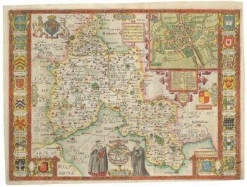
A scarce edition of John Speed’s map of Oxfordshire
£1,600SPEED, John.
Published In 1616
Stock No. 24019 -

A detailed sea chart of the environs of Waitangi in New Zealand
£1,250DUPERREY, Louis-Isidore.
Published In 1829
Stock No. 23961 -

A detailed sea chart of the environs of Manawaora in New Zealand
£1,200DUPERREY, Louis-Isidore.
Published In 1829
Stock No. 23959 -

A French serio-comic map of Europe for the Great War
£1,850CRETE, B.
Published In 1915
Stock No. 23347 -

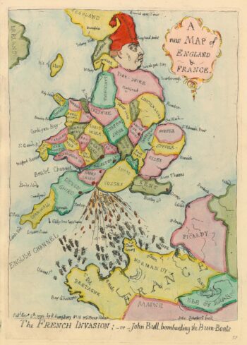
Caricature map of England in danger of invasion, from Gillray’s cruder output
£1,250GILLRAY, James.
Published In 1851
Stock No. 24158 -

Map of the city and university of Oxford
£240MOULE, Thomas.
Published In 1848
Stock No. 23657