- Reset all
- Atlases
- Azores
- Balearics
- Balkan maps
- Bolivia
- Buckinghamshire
- Burma
- Central Asia
- Cyprus
- Devon
- Europe Continent
- Florida
- Germany
- Gibraltar
- Globes and Instruments
- Great Lakes
- Greece
- Gulf States
- Indonesia
- Ionian Islands
- Lancashire
- Latvia and Estonia
- Lincolnshire
- London Localities
- Map Games
- Marche
- Maritime
- New York
- Panama
- Pennsylvania
- Portugal
- Rutland
- Sardinia
- Scottish Islands
- Southern Europe
- Suffolk
- Sussex
- Switzerland
- Tuscany
- Ukraine
- Umbria
- World
- Yorkshire
Showing 13–24 of 854 results
-

A rare lifetime printing of Blaeu’s view of Vesuvius erupting in 1631
£1,400BLAEU, Johannes.
Published In 1663
Stock No. 24506 -

A monumental 18th century wall map of Switzerland on four sheets
£6,500SCHEUCHZER, Johann Jakob.
Published In 1712
Stock No. 24499 -

One of the earliest world maps available to the collector
£15,000SCHEDEL, D. Hartmann.
Published In 1493
Stock No. 24528 -

A very fine early 19th century miniature atlas
£2,250REMONDINI, Giuseppe Antonio.
Published In 1801
Stock No. 24527 -

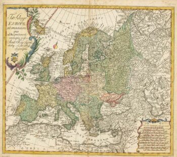
18th century map of Europe
£440EULER, Leonhard.
Published In 1760
Stock No. 24111 -

An instructional card explaining shipboard directions
£220Anonymous.
Published In 1840
Stock No. 24472 -

Gwynn’s proposed improvements between modern Moorgate and Bank.
£300GWYNN, John
Published In 1766
Stock No. 24084 -

An 18th century city map and prospect of Florence
£1,350HOMANN HEIRS.
Published In 1731
Stock No. 24446 -

A late 18th century map of India.
£700MANNERT, Konrad.
Published In 1797
Stock No. 24481 -

A late-18th century plan of Geneva
£250ANDREWS, John.
Published In 1800
Stock No. 24514 -

A late-18th century plan of Berlin
£260ANDREWS, John.
Published In 1800
Stock No. 24513 -

A plan of Puducherry at the beginning of the 18th century
£250FER, Nicolas de.
Published In 1705
Stock No. 24511