Showing 1–12 of 61 results
-

Ortelius’s pocket atlas with the Galle maps in fine colour
£14,000ORTELIUS, Abraham.
Published In 1595
Stock No. 24476 -

A very fine early 19th century miniature atlas
£2,250REMONDINI, Giuseppe Antonio.
Published In 1801
Stock No. 24527 -

The famous 17th century map of Italy by John Speed
£2,500SPEED, John.
Published In 1665
Stock No. 23988 -

An upside-down bird’s-eye view of Italy from the Alps
£950VALLARDI, Antonio.
Published In 1865
Stock No. 24387 -

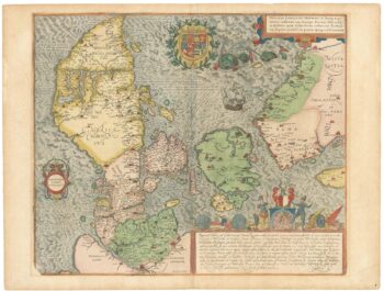
A superb 16th century map of Denmark
£2,000JORDAN, Mark.
Published In 1588
Stock No. 23838 -

Ortelius’s map of Italy in classical times
£1,200ORTELIUS, Abraham.
Published In 1595
Stock No. 23778 -

Charming map of Italy with plans and views of cities
£480LA FEUILLE, Daniel de.
Published In 1707
Stock No. 23644 -

An early 18th century map of Italy
£750HALMA, Fran?ois.
Published In 1704
Stock No. 23638 -

A scarce 16th century map of the South Pole and the Strait of Magellan
£3,000WYTFLIET, Cornelis van.
Published In 1597
Stock No. 23439 -

A separately-issued map of Denmark, the earliest dated map by de Wit
£750DE WIT, Frederick.
Published In 1659
Stock No. 23255 -
18th century map of Italy marking postal routes
£900BAUDRAND, Michel Antoine.
Published In 1750
Stock No. 23207 -

A 17th century map of the early exploration of the Arctic Circle
£1,250BLAEU, Johannes.
Published In 1662
Stock No. 23200