Showing 1–12 of 168 results
-

A map illustrating the British dominance of the seas
£450LONDON GEOGRAPHICAL INSTITUTE.
Published In 1922
Stock No. 24508 -

The Peutinger Table, one of the few surviving examples of Roman cartography
£2,000JANSSON, Jan.
Published In 1700
Stock No. 24492 -

Magini’s edition of Ptolemy’s Geography
£6,000MAGINI, Giovanni Antonio.
Published In 1598
Stock No. 24449 -

A scarce 17th century prospect of Villefranche-sur-Mer
£1,500BLAEU, Johannes.
Published In 1682
Stock No. 24159 -

A miniature double-hemisphere world.
£600SANSON, Nicolas.
Published In 1735
Stock No. 22316 -

16th century woodblock map of France
£380MUNSTER, Sebastian.
Published In 1572
Stock No. 24580 -

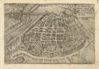
A 16th century town plan of Avignon
£150VALEGIO, Francesco.
Published In 1598
Stock No. 24211 -
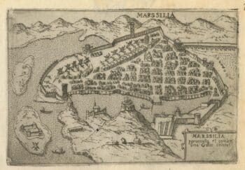
A 16th century town plan of Marseilles
£200VALEGIO, Francesco.
Published In 1598
Stock No. 24210 -

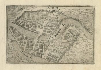
A 16th century town plan of Lyon
£150VALEGIO, Francesco.
Published In 1598
Stock No. 24209 -

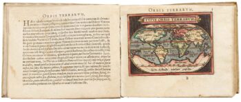
Ortelius’s pocket atlas with the Galle maps in fine colour
£14,000ORTELIUS, Abraham.
Published In 1595
Stock No. 24476 -

A serio-comic map satirising Ronald Reagan’s view of the World
£650HORSEY, David.
Published In 1984
Stock No. 24474 -

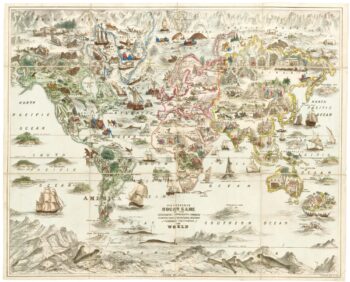
A Victorian game map of the world.
£5,500JONES, Thomas Henry.
Published In 1845
Stock No. 24423