Showing 1–12 of 71 results
-

A large scale map of Westmorland in fine colour
£1,500GREENWOOD, C. & J.
Published In 1824
Stock No. 24069 -

Set of three gores covering Australia from Coronelli’s 42 inch globe
£4,500CORONELLI, Vincenzo Maria.
Published In 1693
Stock No. 23726 -

A detailed 19th century survey of South Australia
£950HARRIS, W.G.
Published In 1862
Stock No. 24105 -

Folding map of Australia with fine colour
£980WYLD, James.
Published In 1833
Stock No. 24071 -

Decorative 18th century map of Norway
£460HOMANN, Johann Baptist.
Published In 1720
Stock No. 24171 -

An 18th century map of the Virgin Islands
£700EDWARDS, Bryan.
Published In 1794
Stock No. 24169 -

A rare issue of Speed’s map of Westmorland
£550SPEED, John.
Published In 1665
Stock No. 24006 -

The first map of Australia by an Englishman
£8,500DUDLEY, Robert.
Published In 1646
Stock No. 23777 -

An unusual Italian map of Australia
£650MARMOCCHI, Francesco C.
Published In 1858
Stock No. 23588 -

A mid-19th century map of Victoria marking the gold fields
£150TALLIS, John.
Published In 1851
Stock No. 23543 -

The first published chart of Macquarie Harbour in Tasmania
£1,200DUPERREY, Louis-Isidore.
Published In 1829
Stock No. 23960 -

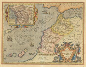
A 16th century map of Morocco
£700ORTELIUS, Abraham.
Published In 1601
Stock No. 23718