Showing 1–12 of 157 results
-

A 16th century woodcut map of Poland, Lithuania and Hungary
£700MUNSTER, Sebastian.
Published In 1572
Stock No. 24574 -

A scarce 18th century map of the Polish-Lithuanian Commonwealth
£950NOLIN, Jean Baptiste jnr.
Published In 1742
Stock No. 24544 -

A 17th century map of Poland
£750DE ROSSI, Giovanni Giacomo.
Published In 1685
Stock No. 24518 -

Four scarce Italian playing cards depicting Poland
£850Anonymous.
Published In 1790
Stock No. 24241 -

16th century woodblock map of Silesia
£300MUNSTER, Sebastian.
Published In 1572
Stock No. 24582 -

16th century woodblock map of Slovenia and Croatia
£375MUNSTER, Sebastian.
Published In 1572
Stock No. 24581 -
A 16th century woodcut map of Greece
£380MUNSTER, Sebastian.
Published In 1572
Stock No. 24576 -

Seven scarce Italian playing cards depicting the Balkans and Greece
£480Anonymous.
Published In 1790
Stock No. 24361 -

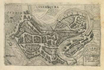
A 16th century town plan of Luxembourg
£300VALEGIO, Francesco.
Published In 1598
Stock No. 24201 -
A 16th century town plan of Rhodes
£250ROTA, Martin.
Published In 1598
Stock No. 24199 -

A 16th century town plan of Corfu City
£250VALEGIO, Francesco.
Published In 1598
Stock No. 24181 -

A 16th century town plan of Heraklion
£150VALEGIO, Francesco.
Published In 1598
Stock No. 24180