Showing 1–12 of 91 results
-

A 17th century chart of the eastern Mediterranean in fine colour.
£1,600DE WIT, Frederick.
Published In 1745
Stock No. 24490 -

de Hooghe’s spectacular chart of the Mediterranean Sea
£36,500HOOGHE, Romeyn de.
Published In 1694
Stock No. 24488 -

Uncommon 16th century Italian map of Cyprus
£1,600ROSACCIO, Giuseppe.
Published In 1598
Stock No. 24538 -

A late-18th century plan of Vienna
£230ANDREWS, John.
Published In 1800
Stock No. 24512 -

Miniature map of Cyprus and the islands of the Aegean
£350HONDIUS, Jodocus II.
Published In 1610
Stock No. 24510 -

A map of the Russo-Turkish War of 1877-8
£250ILLUSTRATED LONDON NEWS.
Published In 1877
Stock No. 24378 -

16th century map with Cyprus & Crete
£900ORTELIUS, Abraham.
Published In 1573
Stock No. 24407 -

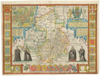
A rare issue of Speed’s map of Cambridgeshire
£2,200SPEED, John.
Published In 1665
Stock No. 24020 -

An early 19th century circular map of the environs of Cambridge
£400RICHARDSON, J.
Published In 1828
Stock No. 23649 -

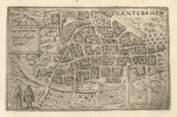
A 16th century Italian plan of Cambridge
£500VALEGIO, Francesco.
Published In 1598
Stock No. 24132 -

Ortelius’s map of the province of Salzburg, in fine colour
£600ORTELIUS, Abraham.
Published In 1612
Stock No. 23808 -

A scarce German edition of Pocock’s map of Cyprus
£650POCOCKE, Richard.
Published In 1745
Stock No. 23804