Showing 1–12 of 28 results
-

A late-18th century plan of Vienna
£230ANDREWS, John.
Published In 1800
Stock No. 24512 -

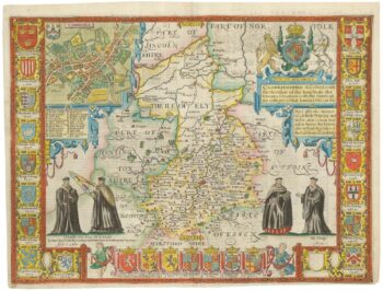
A rare issue of Speed’s map of Cambridgeshire
£2,200SPEED, John.
Published In 1665
Stock No. 24020 -

18th century illustration of a sundial
£160THOMAS, Corbinianus.
Published In 1730
Stock No. 21490 -

An early 19th century circular map of the environs of Cambridge
£400RICHARDSON, J.
Published In 1828
Stock No. 23649 -

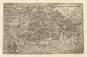
A 16th century Italian plan of Cambridge
£500VALEGIO, Francesco.
Published In 1598
Stock No. 24132 -

A 17th century illustration of an armillary sphere
£180MALLET, Alain Manesson.
Published In 1683
Stock No. 23928 -

Ortelius’s map of the province of Salzburg, in fine colour
£600ORTELIUS, Abraham.
Published In 1612
Stock No. 23808 -

A 17th century map of Austria
£350HONDIUS, Jodocus II.
Published In 1635
Stock No. 23746 -

Map of the Channel Islands of Jersey & Guersney
£125TALLIS, John.
Published In 1851
Stock No. 23517 -

Mid 19th century map of Austria and the Habsburg Empire
£160TALLIS, John.
Published In 1851
Stock No. 23497 -

An 18th century illustration of an armillary sphere
£950DESNOS, Louis Charles.
Published In 1781
Stock No. 23289 -

Miniature map of Hertfordshire, Bedfordshire and Cambridgeshire
£75PERROT, Aristide Michel.
Published In 1828
Stock No. 23136