Showing 1–12 of 24 results
-

A late-18th century plan of Vienna
£230ANDREWS, John.
Published In 1800
Stock No. 24512 -

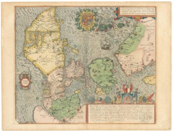
A superb 16th century map of Denmark
£2,000JORDAN, Mark.
Published In 1588
Stock No. 23838 -

Ortelius’s map of the province of Salzburg, in fine colour
£600ORTELIUS, Abraham.
Published In 1612
Stock No. 23808 -

A 17th century map of Austria
£350HONDIUS, Jodocus II.
Published In 1635
Stock No. 23746 -

Mid 19th century map of Austria and the Habsburg Empire
£160TALLIS, John.
Published In 1851
Stock No. 23497 -

A separately-issued map of Denmark, the earliest dated map by de Wit
£750DE WIT, Frederick.
Published In 1659
Stock No. 23255 -

Mid 19th century map of Tibet, Mongolia and Manchuria
£160TALLIS, John.
Published In 1851
Stock No. 21614 -

A 17th century map of Austria
£400JANSSON, Jan.
Published In 1650
Stock No. 20320 -

An early 19th century map of Denmark in fine colour
£160LAURIE & WHITTLE.
Published In 1801
Stock No. 22819 -

A two-sheet woodcut prospect of Vienna in the 16th century
£550MUNSTER, Sebastian.
Published In 1548
Stock No. 22492 -

A mid 19th century map of Denmark with decorative vignettes
£125TALLIS, John.
Published In 1851
Stock No. 21622 -

A scarce plan of Innsbruck with vignettes
£750TEPLY, Josef.
Published In 1840
Stock No. 21208