Showing 1–12 of 28 results
-

A map of the Russo-Turkish War of 1877-8
£250ILLUSTRATED LONDON NEWS.
Published In 1877
Stock No. 24378 -

An important 16th century plan of Angra
£2,800LINSCHOTEN, Jan Huygen van.
Published In 1595
Stock No. 23737 -

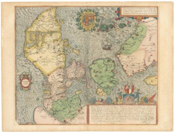
A superb 16th century map of Denmark
£2,000JORDAN, Mark.
Published In 1588
Stock No. 23838 -

A separately-issued map of Denmark, the earliest dated map by de Wit
£750DE WIT, Frederick.
Published In 1659
Stock No. 23255 -

An 18th century map of the Black Sea and surrounds
£450SEUTTER, Matthaus.
Published In 1730
Stock No. 23210 -

Mid 19th century map of the Black Sea
£150TALLIS, John.
Published In 1860
Stock No. 18558 -

A prospect of Aleppo in the 17th century by a professional artist
£680BRUYN, Cornelis de.
Published In 1714
Stock No. 23082 -

An early 19th century map of Denmark in fine colour
£160LAURIE & WHITTLE.
Published In 1801
Stock No. 22819 -

18th century map of the Falkland Islands
£100LODGE, John.
Published In 1770
Stock No. 22014 -

Mid 19th century map of the Province of Syria
£130TALLIS, John.
Published In 1851
Stock No. 21799 -

A mid 19th century map of Denmark with decorative vignettes
£125TALLIS, John.
Published In 1851
Stock No. 21622 -

A 16th century miniature map of Terceira
£150LANGENES, Barent.
Published In 1599
Stock No. 21295