Showing 1–12 of 172 results
-

Zatta’s important map showing Cook’s charting of New Zealand
£1,750ZATTA, Antonio.
Published In 1778
Stock No. 24601 -

Map of Australia and New Zealand after Cook’s First Voyage to the Pacific
£1,000ZATTA, Antonio.
Published In 1776
Stock No. 24599 -

A late Victorian plan of Brighton.
£1,100TREACHER, H. & C.
Published In 1890
Stock No. 24546 -

A 16th century woodcut map of Greece
£380MUNSTER, Sebastian.
Published In 1572
Stock No. 24576 -

The uncommon Spanish edition of Blaeu’s map of Hertfordshire
£450BLAEU, Johannes.
Published In 1662
Stock No. 24521 -

John Oxley’s mapping of New South Wales
£280HALL, Sidney.
Published In 1828
Stock No. 24519 -

A 16th century town plan of Rhodes
£250ROTA, Martin.
Published In 1598
Stock No. 24199 -

A 16th century town plan of Corfu City
£250VALEGIO, Francesco.
Published In 1598
Stock No. 24181 -

A 16th century town plan of Heraklion
£150VALEGIO, Francesco.
Published In 1598
Stock No. 24180 -

The famous scene the Virginians’ Manner of Dancing at their Religious Festivals
£1,900WHITE, John.
Published In 1619
Stock No. 24424 -

A large scale map of Sussex in fine colour
£2,800GREENWOOD, C. & J.
Published In 1825
Stock No. 24224 -

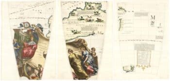
Set of three gores covering Australia from Coronelli’s 42 inch globe
£4,500CORONELLI, Vincenzo Maria.
Published In 1693
Stock No. 23726