Showing 1–12 of 34 results
-

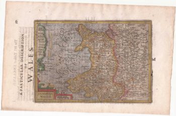
The scarce second state of the Lhuyd-Hondius map of Wales
£550LHUYD, Humfrey.
Published In 1638
Stock No. 23841 -

The first British atlas map of Wales
£1,700SPEED, John.
Published In 1665
Stock No. 23789 -

17th century map of Dorset
£600BLAEU, Johannes.
Published In 1662
Stock No. 22703 -

Miniature map of Cardiganshire, Randorshire and Brecknockshire
£75PERROT, Aristide Michel.
Published In 1828
Stock No. 23106 -

Miniature map of Merionethshire and Montgomeryshire
£150PERROT, Aristide Michel.
Published In 1828
Stock No. 23105 -
Miniature map of map of Anglesey
£150PERROT, Aristide Michel.
Published In 1828
Stock No. 23073 -

Blaeu’s map of Pembrokeshire and Carmarthenshire, with fine colour
£500BLAEU, Johannes.
Published In 1662
Stock No. 23042 -

A 17th century townplan of Newport
£160HERMANNIDES, Rutger.
Published In 1661
Stock No. 22781 -

Lhuyd’s map of Wales, as published in a historical atlas
£650LHUYD, Humfrey.
Published In 1700
Stock No. 22741 -

Wales from the first English Edition of the ‘Atlas Minor’
£125HONDIUS, Jodocus.
Published In 1635
Stock No. 22450 -

An early issue of Blaeu’s map of Wales, with fine colour
£950BLAEU, Johannes.
Published In 1645
Stock No. 22266 -

Early 17th century map of Wales
£900LHUYD, Humfrey.
Published In 1619
Stock No. 22265