Showing 1–12 of 165 results
-

Zatta’s important map showing Cook’s charting of New Zealand
£1,750ZATTA, Antonio.
Published In 1778
Stock No. 24601 -

An 18th century map of North America
£1,200WEIGEL, Christoph.
Published In 1718
Stock No. 24541 -

16th century map of the Kingdom of Naples
£650ORTELIUS, Abraham.
Published In 1595
Stock No. 24444 -

A mid-18th century map of North America
£850LOTTER, Tobias Conrad.
Published In 1765
Stock No. 24610 -

16th century woodblock map of Slovenia and Croatia
£375MUNSTER, Sebastian.
Published In 1572
Stock No. 24581 -
A 16th century woodcut map of Greece
£380MUNSTER, Sebastian.
Published In 1572
Stock No. 24576 -

Seven scarce Italian playing cards depicting the Balkans and Greece
£480Anonymous.
Published In 1790
Stock No. 24361 -

A 16th century town plan of Rhodes
£250ROTA, Martin.
Published In 1598
Stock No. 24199 -

A 16th century town plan of Corfu City
£250VALEGIO, Francesco.
Published In 1598
Stock No. 24181 -

A 16th century town plan of Heraklion
£150VALEGIO, Francesco.
Published In 1598
Stock No. 24180 -

A 16th century town plan of Dubrovnik
£250VALEGIO, Francesco.
Published In 1598
Stock No. 24175 -

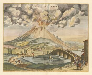
A rare lifetime printing of Blaeu’s view of Vesuvius erupting in 1631
£1,400BLAEU, Johannes.
Published In 1663
Stock No. 24506