Showing 1–12 of 154 results
-

16th century woodblock map of Slovenia and Croatia
£375MUNSTER, Sebastian.
Published In 1572
Stock No. 24581 -
A 16th century woodcut map of Greece
£380MUNSTER, Sebastian.
Published In 1572
Stock No. 24576 -

Seven scarce Italian playing cards depicting the Balkans and Greece
£480Anonymous.
Published In 1790
Stock No. 24361 -

A 16th century town plan of Rhodes
£250ROTA, Martin.
Published In 1598
Stock No. 24199 -

A 16th century town plan of Corfu City
£250VALEGIO, Francesco.
Published In 1598
Stock No. 24181 -

A 16th century town plan of Heraklion
£150VALEGIO, Francesco.
Published In 1598
Stock No. 24180 -

A 16th century town plan of Dubrovnik
£250VALEGIO, Francesco.
Published In 1598
Stock No. 24175 -

Sir William Petty’s mapping of Ireland
£1,500LEA, Philip.
Published In 1689
Stock No. 24379 -
An early issue of Jansson’s map of Ireland
£950JANSSON, Jan.
Published In 1638
Stock No. 23865 -

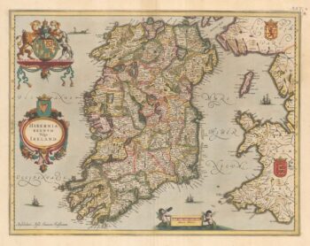
An uncommon state of Mercator’s pair of maps of Ireland
£1,250MERCATOR, Gerard.
Published In 1638
Stock No. 23864 -

One of the earliest versions of Sophianos’s map of Greece
£14,000BERTELLI, Ferrando
Published In 1564
Stock No. 24220 -

Miniature map of Donegal
£85PERROT, Aristide Michel.
Published In 1828
Stock No. 23300