Showing 1–12 of 50 results
-

A view of the Battle of Lepanto engraved in 1572
£2,500CAVALIERI, Giovanni Battista de'.
Published In 1647
Stock No. 24486 -
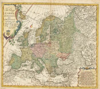
18th century map of Europe
£440EULER, Leonhard.
Published In 1760
Stock No. 24111 -

An instructional card explaining shipboard directions
£220Anonymous.
Published In 1840
Stock No. 24472 -

First issue of Rumold Mercator’s map of Europe
£2,500MERCATOR, Rumold.
Published In 1595
Stock No. 24298 -

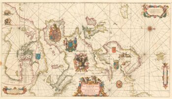
An exceptional 17th century sea chart of Europe on two sheets
£7,500DE WIT, Frederick.
Published In 1675
Stock No. 23450 -

A two-sheet map of Europe
£1,000JAILLOT, Alexis-Hubert.
Published In 1705
Stock No. 24059 -
The largest representation of Hawaii to appear in an atlas
£900VANDERMAELEN, Philippe.
Published In 1827
Stock No. 24396 -

A decorative marine print of early 18th century warships
£1,250HOMANN, Johann Baptist.
Published In 1730
Stock No. 24163 -

An 18th century maritime explanatory print
£1,200CHATELAIN, Henri Abraham.
Published In 1720
Stock No. 24154 -

18th century map of the Caspian Sea & Uzbekistan
£950MAAS, Abraham.
Published In 1735
Stock No. 24091 -

A 17th century map of the Roman Empire
£1,600SPEED, John.
Published In 1627
Stock No. 23989 -

17th century English carte ? figure map of Europe
£2,600SPEED, John.
Published In 1665
Stock No. 23986