Showing 1–12 of 59 results
-

An unusual 18th century map of the Holy Land
£800SEUTTER, Matth?us.
Published In 1745
Stock No. 24605 -

A plan of Jerusalem after Adrichom
£750SEUTTER, Matth?us.
Published In 1730
Stock No. 24600 -

An early woodcut map of the Holy Land
£850MUNSTER, Sebastian.
Published In 1552
Stock No. 24569 -

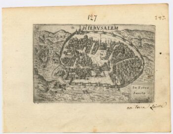
17th century prospect of Biblical Jerusalem
£1,000DAPPER, Olfert.
Published In 1677
Stock No. 24540 -

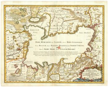
An 18th century map of the Caspian Sea
£700DE ROSSI, Domenico.
Published In 1723
Stock No. 24517 -

A scarce map of the Holy Land in the 18th century
£250FER, Nicolas de.
Published In 1707
Stock No. 24525 -

A scarce map of the Holy Land in Biblical times
£250FER, Nicolas de.
Published In 1707
Stock No. 24524 -

A 16th century town plan of Jerusalem
£450VALEGIO, Francesco.
Published In 1598
Stock No. 24161 -

16th century map of the Eastern Mediterranean in rare early colour
£880MUNSTER, Sebastian.
Published In 1550
Stock No. 24441 -

A view of the Battle of Lepanto engraved in 1572
£2,500CAVALIERI, Giovanni Battista de'.
Published In 1647
Stock No. 24486 -

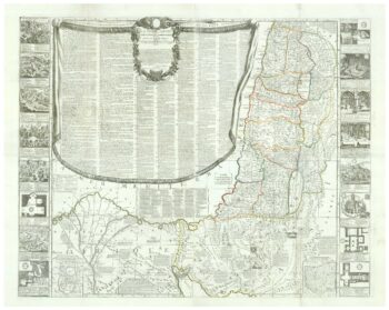
A rare wall map of the Holy Land
£9,000NOLIN, Jean Baptiste.
Published In 1785
Stock No. 24500 -

An instructional card explaining shipboard directions
£220Anonymous.
Published In 1840
Stock No. 24472