Showing 1–12 of 13 results
-

A monumental sea chart of south-west England
£3,250HOOGHE, Romeyn de.
Published In 1693
Stock No. 24483 -

A rare 17th century Dutch sea chart of the British Isles
£1,400DONCKER, Hendrik.
Published In 1665
Stock No. 22272 -

A pictorial map of Beijing in the 1930s
£3,000DORN, Frank.
Published In 1936
Stock No. 24392 -

An 18th century two-sheet sea chart of the English Channel based on Halley
£1,250MOUNT & PAGE.
Published In 1745
Stock No. 23424 -

A scarce issue of John Speed’s map of Cumberland
£700SPEED, John.
Published In 1665
Stock No. 24024 -

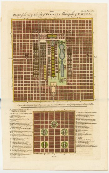
18th century town plan of Peking
£450HARRIS, John.
Published In 1748
Stock No. 23674 -
An 18th century sea chart of the English Channel
£450JEFFERYS, Thomas.
Published In 1775
Stock No. 23417 -

The arrival of the VOC Embassy at Beijing
£550NIEUHOFF, Johan.
Published In 1671
Stock No. 20696 -

A scarce playing-card map of Cumberland
£400ALLEN, Joseph.
Published In 1811
Stock No. 18720 -

Waghenaer’s distinctive sea chart of the Bristol Channel
£2,200WAGHENAER, Lucas Janzoon.
Published In 1591
Stock No. 18369 -

One of the most decorative maps of Bermuda
£2,000ZATTA, Antonio.
Published In 1778
Stock No. 16570 -

An important chart of the east coasts of England
£650MOUNT & PAGE.
Published In 1747
Stock No. 15582