Showing 1–12 of 92 results
-

A pictorial map of Beijing in the 1930s
£3,000DORN, Frank.
Published In 1936
Stock No. 24392 -

Van der Aa’s large format maps of the four Continents in superb colour
£7,500AA, Pieter van der.
Published In 1713
Stock No. 24369 -

Early illustration of the Ring Nebula
£175BLUNT, Charles F.
Published In 1845
Stock No. 24335 -

An early illustration of the Nebula of Orion
£175BLUNT, Charles F.
Published In 1845
Stock No. 24333 -
An early illustration of the Nebula of Andromeda
£175BLUNT, Charles F.
Published In 1845
Stock No. 24332 -

Nebula of Hercules
£175BLUNT, Charles F.
Published In 1845
Stock No. 24331 -

Chart of the Milky Way
£175BLUNT, Charles F.
Published In 1845
Stock No. 24277 -

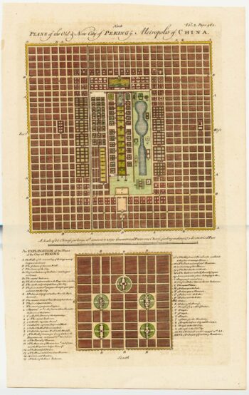
18th century town plan of Peking
£450HARRIS, John.
Published In 1748
Stock No. 23674 -

Mid 19th century map of Tibet, Mongolia and Manchuria
£160TALLIS, John.
Published In 1851
Stock No. 21614 -

18th century map of Serpens, Serpentarius and Scutum
£350THOMAS, Corbinianus.
Published In 1730
Stock No. 21411 -

18th century illustration of the constellation Lyra
£300THOMAS, Corbinianus.
Published In 1730
Stock No. 21404 -

The world & continents from the ‘Atlas Major’
£35,000BLAEU, Johannes.
Published In 1662
Stock No. 20269