Showing 1–12 of 30 results
-

A pictorial map of Beijing in the 1930s
£3,000DORN, Frank.
Published In 1936
Stock No. 24392 -

Van der Aa’s large format maps of the four Continents in superb colour
£7,500AA, Pieter van der.
Published In 1713
Stock No. 24369 -

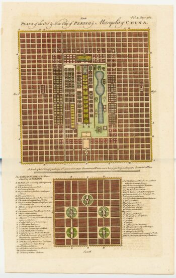
18th century town plan of Peking
£450HARRIS, John.
Published In 1748
Stock No. 23674 -

A rare 18th century view of Marsamxett
£3,750PULLICINO, Alberto.
Published In 1770
Stock No. 23426 -

A rare 18th century view of Valletta
£3,750PULLICINO, Alberto.
Published In 1770
Stock No. 23425 -

A 17th century miniature plan of Valletta
£220MALLET, Alain Manesson.
Published In 1683
Stock No. 22329 -

The world & continents from the ‘Atlas Major’
£35,000BLAEU, Johannes.
Published In 1662
Stock No. 20269 -

A late-18th century plan of Valletta
£280ANDREWS, John.
Published In 1800
Stock No. 22602 -

A bird’s-eye view-map of Malta
£480CALMET, Augustin Antoine.
Published In 1722
Stock No. 21804 -

A 16th century miniature map of Malta
£400LANGENES, Barent.
Published In 1599
Stock No. 21326 -

An 18th century vue d’optique of Valletta Harbour
£850PROBST, Georg Balthasar.
Published In 1760
Stock No. 21231 -

18th century Bird’s-eye view map of Malta
£650PUTTER, Abraham de.
Published In 1729
Stock No. 21022