Showing 1–12 of 18 results
-

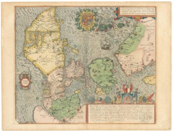
A superb 16th century map of Denmark
£2,000JORDAN, Mark.
Published In 1588
Stock No. 23838 -

A separately-issued map of Denmark, the earliest dated map by de Wit
£750DE WIT, Frederick.
Published In 1659
Stock No. 23255 -

17th century map of Dorset
£600BLAEU, Johannes.
Published In 1662
Stock No. 22703 -

An early 19th century map of Denmark in fine colour
£160LAURIE & WHITTLE.
Published In 1801
Stock No. 22819 -

A mid 19th century map of Denmark with decorative vignettes
£125TALLIS, John.
Published In 1851
Stock No. 21622 -

Scarce map of Denmark
£400WALCH, Johann.
Published In 1820
Stock No. 21119 -

17th century map of Denmark
£475VISSCHER, Nicolas Jansz.
Published In 1670
Stock No. 20730 -

A ‘board game’ map of Europe
£1,250SPOONER, William.
Published In 1842
Stock No. 19586 -

A scarce playing-card map of Dorset
£500ALLEN, Joseph.
Published In 1811
Stock No. 18719 -

Map of Denmark
£50WILKINSON, Robert.
Published In 1828
Stock No. 17580 -

One of the most decorative maps of Bermuda
£2,000ZATTA, Antonio.
Published In 1778
Stock No. 16570 -

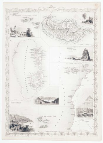
Map of Bermuda and other islands in the Atlantic, with vignettes
£100TALLIS, John.
Published In 1851
Stock No. 12631