Showing 1–12 of 44 results
-

A large four-sheet map of Midlothian
£750KNOX, James.
Published In 1821
Stock No. 23326 -

A Georgian folding map of Linlithgowshire
£800FORREST, William.
Published In 1818
Stock No. 22680 -

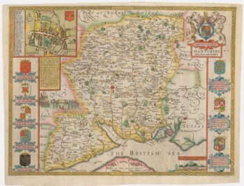
A scarce issue of John Speed’s map of Hampshire
£1,300SPEED, John.
Published In 1665
Stock No. 24040 -
The only map by Timothy Pont published in his lifetime
£450PONT, Timothy.
Published In 1638
Stock No. 23842 -

Miniature map of Middlesex
£45PERROT, Aristide Michel.
Published In 1828
Stock No. 23302 -

17th century map of Middlesex & Hertfordshire
£750JANSSON, Jan.
Published In 1646
Stock No. 23925 -

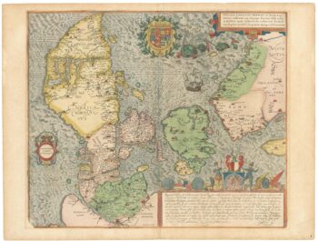
A superb 16th century map of Denmark
£2,000JORDAN, Mark.
Published In 1588
Stock No. 23838 -

A separately-issued map of Denmark, the earliest dated map by de Wit
£750DE WIT, Frederick.
Published In 1659
Stock No. 23255 -

A four-sheet map of Georgian Stirlingshire
£1,500GRASSOM, John.
Published In 1817
Stock No. 22658 -

Miniature map of Wigtown and Kirkcudbrightshire
£90PERROT, Aristide Michel.
Published In 1828
Stock No. 23117 -

Miniature map of Rossshire
£95PERROT, Aristide Michel.
Published In 1828
Stock No. 23115 -

Miniature map of Invernessshire
£95PERROT, Aristide Michel.
Published In 1828
Stock No. 23114