Showing 1–12 of 27 results
-

Dutch broadsheet of the Anglo-Spanish War, 1727-9
£900LETH, Andries de.
Published In 1727
Stock No. 22698 -

A rare issue of Speed’s famous 17th century map of Hungary
£1,500SPEED, John.
Published In 1665
Stock No. 23990 -

Ortelius’s map of Hungary in fine colour
£650ORTELIUS, Abraham.
Published In 1612
Stock No. 23811 -

Ortelius’s map of Hungary in fine original colour
£600ORTELIUS, Abraham.
Published In 1603
Stock No. 23806 -

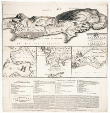
The British capture of Gibraltar in 1704
£800DECKER, Paul.
Published In 1720
Stock No. 23319 -

An 17th century map of the Kingdom of Hungary
£450DE WIT, Frederick.
Published In 1688
Stock No. 23292 -

Dutch sea chart of the harbour of Gibraltar
£450KEULEN, Johannes van.
Published In 1630
Stock No. 22708 -

An 18th century map of Hungary and the northern Balkans
£380SEUTTER, Matthaus.
Published In 1760
Stock No. 22732 -

Hungary from the first English Edition of the ‘Atlas Minor’
£170HONDIUS, Jodocus.
Published In 1635
Stock No. 22392 -

Plan of Gibraltar in 1738
£280BASIRE, James.
Published In 1745
Stock No. 22152 -

18th century Dutch sea chart of the Strait of Gibraltar.
£200TIRION, Isaak.
Published In 1759
Stock No. 22010 -

Gibraltar during the Seven Years’ War
£160GIBSON, John.
Published In 1762
Stock No. 21950