Showing 1–12 of 53 results
-

A rare lifetime printing of Blaeu’s view of Vesuvius erupting in 1631
£1,400BLAEU, Johannes.
Published In 1663
Stock No. 24506 -

A map of the Russo-Turkish War of 1877-8
£250ILLUSTRATED LONDON NEWS.
Published In 1877
Stock No. 24378 -

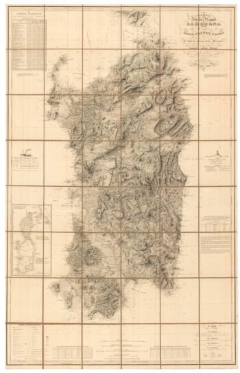
An important 19th century map of Sardinia
£1,100Alberto., Alberto., FERRERO DELLA MARMORA
Published In 1845
Stock No. 24225 -

Mid-19th century map of southern Italy with vignettes
£125TALLIS, John.
Published In 1851
Stock No. 23547 -

A rare map of the Kingdom of Naples
£680NOLIN, Jean Baptiste.
Published In 1705
Stock No. 23637 -

A 17th century old map of the Gulf of Guinea in West Africa
£500JANSSON, Jan.
Published In 1680
Stock No. 23630 -

Map of the Channel Islands of Jersey & Guersney
£125TALLIS, John.
Published In 1851
Stock No. 23517 -

A two-sheet prospect of the Ponte Nuovo, Naples
£3,500RICCIARDELLI, Gabriele.
Published In 1765
Stock No. 23422 -

A two-sheet prospect of Chiaia with the Bay of Naples and Vesuvius
£3,500RICCIARDELLI, Gabriele.
Published In 1765
Stock No. 23421 -

Du Val’s folio map of the slave forts of the Gulf of Guinea
£480DU VAL, Pierre.
Published In 1671
Stock No. 23256 -

An 18th century map of the Black Sea and surrounds
£450SEUTTER, Matthaus.
Published In 1730
Stock No. 23210 -

Mid 19th century map of the Black Sea
£150TALLIS, John.
Published In 1860
Stock No. 18558