Showing 13–24 of 577 results
-

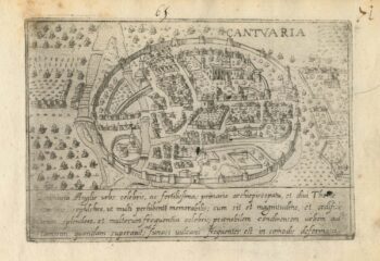
A 16th century Italian plan of Canterbury
£280VALEGIO, Francesco.
Published In 1598
Stock No. 24131 -

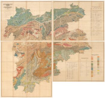
A geological map of the Duchy of Tyrol
£2,350STOTTER, Michael.
Published In 1851
Stock No. 23050 -

A scarce map of Scotland
£1,000BROWNE, Christopher.
Published In 1721
Stock No. 24436 -

Vrients’s scarce map of England, Wales & Ireland
£4,250VRIENTS, Jan Baptist.
Published In 1612
Stock No. 20271 -

A view of the Battle of Lepanto engraved in 1572
£2,500CAVALIERI, Giovanni Battista de'.
Published In 1647
Stock No. 24486 -

A monumental sea chart of south-west England
£3,250HOOGHE, Romeyn de.
Published In 1693
Stock No. 24483 -

An instructional card explaining shipboard directions
£220Anonymous.
Published In 1840
Stock No. 24472 -

A map of the early Church in Egypt and Lybia
£650SANSON, Nicolas.
Published In 1704
Stock No. 24115 -

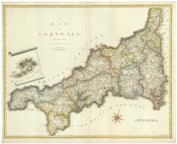
An early 19th century map of Cornwall
£225CARY, John.
Published In 1805
Stock No. 24114 -
Victorian map of China with views of Hong Kong and Canton
£250TALLIS, John.
Published In 1851
Stock No. 23537 -

A rare 17th century Dutch sea chart of the British Isles
£1,400DONCKER, Hendrik.
Published In 1665
Stock No. 22272 -

A large scale map of Sussex in fine colour
£2,800GREENWOOD, C. & J.
Published In 1825
Stock No. 24224